


ANGOLA/NAMIBIA: PGS Delivers Continuous 3D Data Coverage of Southern Namibe Basin
Final PSTM and PSDM products are now available from PGS’ latest MultiClient 3D surveys in the Namibe Basin of Angola and Namibia.
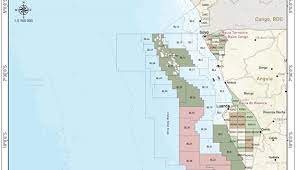
New 3D GeoStreamer seismic coverage brings fresh understanding for exploration in deepwater blocks 29, 30, 44, and 45 in Angola, and blocks 1710, 1711, 1810, and 1811A in Namibia.
Namibe Basin Revealed
PGS’ ANG Namibe 2020 3D GeoStreamer dataset targets over 14 000 sq. km, adjacent to the ANG Namibe 2014 3D survey. The NAM 2019 3D GeoStreamer survey covers over 8 900 sq. km of exploration acreage in the Namibian sector of the basin.
PGS now offers continuous coverage of the southern Namibe basin, with final products comprising over 34 000 sq. km of high-quality broadband seismic data, tying into important exploration and ODP wells.
Regional 3D GeoStreamer data, incorporating FWI velocity model building, will help to establish target plays and traps in the southern Namibe Basin through better imaging of structure and basin fill.

ANG Namibe 2020 and NAM 2019 expand 3D coverage of the basin revealing plays and traps with improved FWI-driven imaging of structure and basin fill
Regional 3D Delineation of Play Elements to Derisk Exploration
Basin-wide broadband coverage enables the mapping of Cretaceous through to Tertiary play elements in a basin framework, facilitating the identification of sweet spots and derisking further exploration.

This final PSDM full-stack line from the ANG Namibe 2020 3D GeoStreamer survey demonstrates the high quality of the imaging, showing (1) early post-rift basin-fill containing widespread soft events (candidate source rocks), and (2) overlying interpreted clastic fairways pinching out up-dip.
